On Saturday we rode further than we’ve ridden in several months, which isn’t saying much. We’ve been so busy with moving to a new city and working on business development for Joycycling Services that it’s been hard to find the time, even when the weather has been ideal. And since we moved down to Pueblo, we haven’t ridden as far as we’d like because we’re still trying to figure out the routes around here, and where we can ride from the house in which we’re currently living.
On one ride, Angie went around a corner, only to find that the path had completely collapsed (we assume because of floods). Fortunately, she was able to stop pretty quickly without taking a tumble 20 or so feet down into Fountain Creek. And our most direct route to get on the path towards the state park closed last week without any signage or forewarning, though we’ve now found a way around that.
We really enjoyed yesterday’s ride, and actually only turned around because we reached the park boundary at Lake Pueblo State Park, where the path was under repair. Thanks to Great Outdoors Colorado (and people who play the lottery) the roads and paved trails in the park are being overhauled. Apparently, the roads are 30 years old, so they kind of need it, and I can attest to the quality of the paved paths hitherto, since when I rode there in the fall it seemed like there was a big crack every 15 or 20 feet.
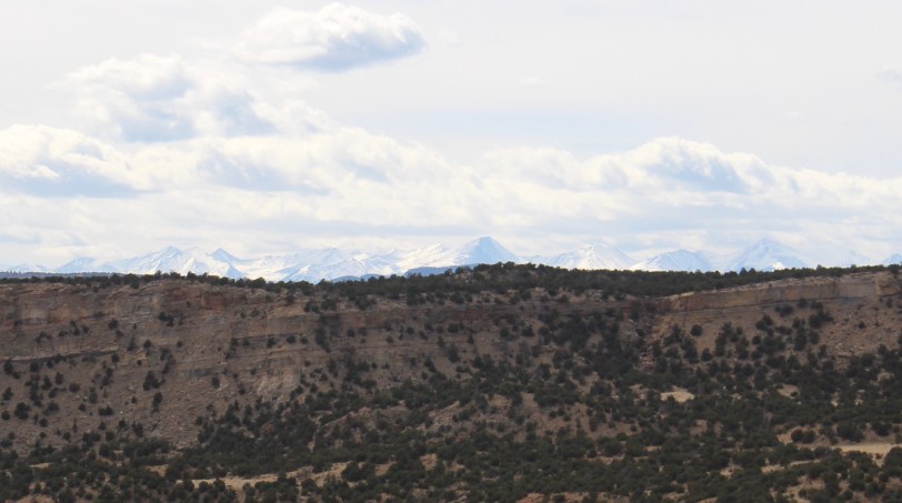
This is a view from shortly after we turned back toward home.

Our ride home involved a bit more wayfinding, since we didn’t want to do an “out-and-back” ride. We thought we’d be able to go out along the road that takes people out of the Nature Center and then up along 11th Street, but then (after a nice little 8% grade to get up to the Raptor Center), we saw that 11th Street looked like it was a nasty little “bridge hill” on which you might have to ride with the traffic, which was quite heavy at the time. We decided we will save riding that for another day (maybe), after we’ve driven it and checked out how safe the shoulder might be. So we punted and rode along the bike path that is nicely separated from the traffic along Pueblo Boulevard. It’s not long before it rejoins the Arkansas River Multiuse Path. We found our way round the closed path at Wildhorse Creek and meandered our way home along the nasty little bridge hill on 18th Avenue and the ugly little grind as you approach Parkview Hospital. With a couple of nasty little inclines on the way home, we were pretty whipped by the time we finished.
Between that and the unexpectedly gusty winds that greeted us when we got up this morning, I was only too happy to agree to Angie’s excellent suggestion that we take a field trip today to hike at Oil Well Flats, which is on Bureau of Land Management land. Like Lake Pueblo State Park, Oil Well Flats is an increasingly popular gem for mountain bikers in the state. Since I’m not much of a mountain biker, and Angie had her little spill this week, we thought a great way to reconnoiter the area would be to hike on some of the paths. That way, we can figure out on which routes I might be able to hold my own.
We decided to stop in Cañon City for a bite to eat before we hit the trail and were lucky enough to find the Good Thyme Café, which seems to be family owned–just up our alley. We felt very welcomed and really appreciated the young lady behind the counter recommending their walking burrito, since we just wanted a cheap and fresh sandwich-type option. At $4 apiece, they were a great value, especially since they were made to order and really tasty and satisfying. After fueling up we wound our way to the lower trailhead.
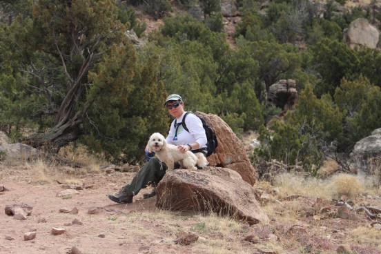
It turned out to be a perfect day for a hike. It was windy in Pueblo, and a bit chilly and windy in Cañon City, but the area of the hike at Oil Well Flats seemed to be somewhat protected, so we actually were pretty warm for most of the hike, except when we were up near the top of the ridge. We had selected Tectonic Shift as our trail of entry. As a mountain biking route it’s intermediate, which meant it wasn’t too hard as a hiking trail. We hiked the trail as far as BLM road 5941, and then walked along that dirt road until it met the unsigned spot where the beginner route Fracture crossed the road. We then took Fracture back to our car via the Upper Trailhead. The route was really pretty, as you can see from this selection of the many photos I took.


We could even see the snowcapped mountains in the Sangre de Cristo range off in the distance:
Tectonic Shift did seem slightly tougher than the Fracture Trail but given how little I’ve ridden singletrack, I would probably want to start with the BLM roads anyway and work my way up! Angie explained that essentially a trail is rated due to how difficult the hardest parts of the trail are. Tectonic Shift definitely had some challenging little hitches to it. We only walked half of Fracture but it did seem mainly more straightforward. I did actually look online about about trail ratings and found this link.
We had expected to hike for about an hour, but in the end we spent closer to 90 minutes on the trail. It was wasn’t too taxing to walk on the trails, and I think Rebbe really enjoyed it too, though he got filthy because of the dust.
By the time he’d gotten home and had his bath, Rebbe was ready to collapse in a heap but we were happy to have enough energy left ourselves to get some more done around the house as we get ready for the week ahead.

Seems as though trails and paths are in need of some rehabbing. Beautiful pictures in a brown sort of way.
Happily, “they” are going to rehab ALL the paved trails in the state park. The trails on the mountain bike part up in Cañon City are all quite dusty but well cared for.